I turned on my camera in my phone holder and snapped a selfie while zipping along on my birthday ride. I turned 62 today.
l started where route 21 and route 2216 intersect. I think the town is called Na Sam in Phetchabun but I have a hard finding the names of places in google maps. I rode about 100 kilometers or 60 miles along route 2216 from that town what ever it's called to route 12 at a town I think is called Thung Phra in Chaiyaphum.
This was recommended to me by a YouTube page Thailand Top Riding Routes. Following is a screen print of the route in the description of the video of this route.
The weather was not great with what felt like god spitting on me the whole day and mostly an overcast sky. It was still a fun ride with lots of twisting and turning road and a lot of ups and downs. It was also rather cool which was a pleasant surprise for me. I think I also saw more tractors than cars for most of route 2216.
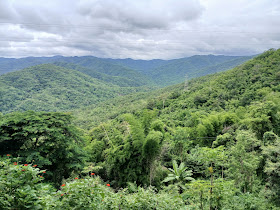
I am not good at stopping and taking pictures and don't have a setup for taking videos while riding. Here are a few pictures I took.
I first thought the last picture was the fruit rambutans but after looking at it awhile I think it's some type of bloom rather than a fruit.
I stopped near the end of 2216 and used the toilet and then had a cup of coffee but didn't fill the motorbike. I know route 12 goes all the way across Thailand so assumed there would be a lot of gas stations. I was wrong.
At the end of 2216 I made a right onto route 12. Once I saw that the road appeared to be entering into a jungle with dense forest on both sides I should have turned around and went back to the gas station at 2216 but I didn't.
I was thinking I had 2 bars and there will be a gas station soon. When I got to one bar I found a place to stop and search Google maps for a gas station. Where I stopped didn't have internet on the phone so no search function.
I continued down route 12 and about 10 kilometers later I stopped and attempted a search again. 2 places popped up that I thought might be reachable. 1 only had a picture of a field and was a little bit further away but was on route 12. The other had a picture of an pump where you insert money and pump yourself. It was a ways off the main route. I selected the closer one off the main route and followed the GPS.
I was pulling away from my parking place when the fuel bar started flashing and I can't remember what distance that means. I think maybe I have 10 kilometers of fuel left. Seems it took me forever to get to the turnoff and it was a dirt road going up a hill.
I reach a small village and think at least someone will help me get fuel here. I keep looking at each place to see if I see one of those stands of liquor bottles with fuel.
I look at my phone again and oh sh!t I've made a wrong turn somewhere. I turn around and see where I missed a turn.
Oh no it seems like I'm leaving the village but the GPS says there is fuel on the other side of that bridge. Everytime Google maps has been wrong keeps running through my mind.
There is what looks like a store and it's where the pump should be and please oh please let the pump be working.
I have never been happier to see a machine like this picture I found on the internet.
I put the pump in my tank stick in a 100 baht bill and hit the green button. The pump is talking to me in Thai and I don't understand a word. I open the pump handle and nothing happens.
I am just staring at the pump when a guy comes out and helps me. I think my problem was the pump handle has to be open before pushing the green button.
I have enough fuel to get to my hotel in Lom Sak. I kept saying thank you, thank you very much and even a few times in English.
The ride back through the village and to the main road seemed much shorter going down.
I stopped at a pull out on route 12 and took one more picture before driving the rest of the way to my hotel.
When I got checked into my hotel I had a couple beers to celebrate my birthday and an interesting day on the bike.


No comments:
Post a Comment